Graphics
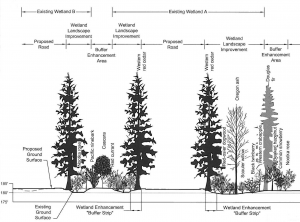
ELS' experienced Computer-Aided Design (CAD) staff is well trained to provide a variety of project related products with the most advanced software and hardware resources. Our CAD department has a long standing reputation for clear, concise, and understandable drawings that reduce the need for agency requested modifications.
- AutoCAD Design
- Custom Graphic Design
- Volumetrics, Topography, Area Calculations
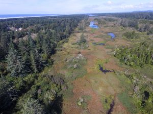
Drone Services
ELS also has drone technology capable of capturing survey quality data in either raster or vector format with the ability to monitor real-time changes to the site in both 2d and 3d. Pix4D is used for the processing of drone imagery and data is exported for use in AutoCAD Civil 3D.
Recent Graphics & Drone Projects